Pararake & Hikurangi landscapes · What the ground itself shows · Puheke & the wider rohe · The Matthews claim at Parapara · Okokori · The land, by the numbers · Legal protections today
Pararake & Hikurangi — the landscapes
Tracing two of our cultural landscapes, Pararake and Hikurangi, and how promised protections were, time and again, not delivered.
Pararake — a promise made, a hill still divided
In 1839, missionary Joseph Matthews agreed to buy land at Parapara with the clear understanding that Pararake, a sacred pā and burial ground, would stay with Ngāti Tara. It didn't hold — by 1859 the Crown had claimed it as "surplus." A 1905 survey even labelled it "Native Reserve Hill," but no reserve was ever legally made. Today it sits split across five titles.
Takapuna urupā — the one that got protected
Not every story ends the same way. Takapuna urupā and the 1880 St Matthews Church were successfully set apart and made "absolutely inalienable" in 1905 — one of only two sites in the rohe the 1908 Stout-Ngata Commission recommended reserving specifically as wāhi tapu.
Hikurangi — sold by people who'd never agreed to sell it
Set aside as a Native Reserve in 1861. In 1868 the Land Court granted title to seven people with no restriction on sale, despite the urupā on it — and three months later, all seven sold it. None of them had signed the original 1861 deed. The judge presiding over that 1868 hearing, W.B. White, was the same official who had personally negotiated and surveyed the original 1861 purchase — and one claimant, Pene Te Kaitoa, told the Court plainly: "we wish to sell it, we have plenty of other land."
Asking, and asking again
In 1923, Heta Kiriwi and 23 others petitioned Parliament over Parapara. The petition was adjourned in 1938 and never resumed. In 1948, Pereene Huirama gave the only oral evidence a Ngāti Tara claimant gave to the Surplus Lands Commission — four generations, still asking.
A second official record — Woodley, 2026
An independent Tribunal-commissioned report confirms a 3-acre portion of Parapara East was officially recorded as "wāhi tapu" in 1908 — and that Puketū Island, named in our claim, was formally set aside as a Māori reservation in 1982.
What the ground itself shows
The companion archaeological survey of Pararake and Hikurangi — physical evidence of pā, kāinga, terraces, pits and burial areas, and what's happened to them since.
"A Sacred Place called Pararaki" — in the Crown's own words
Rev. Joseph Matthews, the missionary who surveyed the land around Pararake himself, told the 1857 Bell Commission it was "a Sacred Place called Pararaki." His own survey map from that year marks the name at the centre of the block. The archaeological survey confirms why: skeletal remains — three crania and bundles of bone, partly covered by soil under large rocks — in a boulder-field burial area beside the pā.
Bulldozed before anyone wrote it down
Most of the ~68 archaeological sites recorded around Hikurangi Pā — terraces, pits, middens, an adze findspot — were first entered into the national site record in 1996, during land clearing for a pine plantation. By the surveyors' own account, several hundred hectares had already been "roughly cleared and/or burnt" before anyone documented what was there, leaving the sites "badly damaged and in poor to fair condition" from the outset. The large burial area on the mountain's southern flank has likely never been formally investigated at all.
Findings above drawn from Justin Maxwell & Jennifer Huebert, "Ngāti Tara: Wāhi Tapu and Portable Taonga, Volume II: Archaeological Report" (Crown Forestry Rental Trust, Wai 45 #T30, March 2025).
Puheke & the wider rohe
Parapara and Hikurangi aren't the only places this happened. Puheke, further north on the Karikari Peninsula, tells the same story.
Puheke — 16,000 acres, and "grossly under-estimated" from the start
Puheke — burial and interment sites, waka landing places, and the wāhi tapu Ōtamawhakaruru all within its bounds — was purchased by the Crown in 1859 alongside the neighbouring Waiake block (6,950 acres). Puheke itself came to 16,000 acres. The Tribunal's own 1997 Muriwhenua Land Report didn't mince words about how that purchase was handled: "The size of the Puheke purchase was grossly under-estimated, again indicating the regular looseness in proceedings."
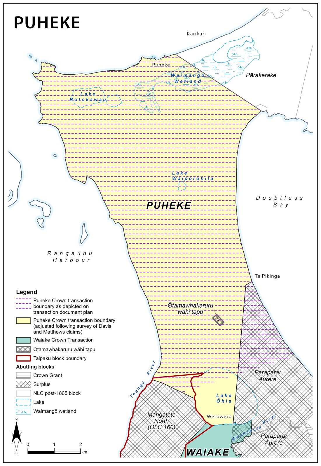
Source: Mulder, Pre-1865 Crown Transactions and Reserves, p.42, 48 → · Muriwhenua Land Report, 1997, p.402 →
The Matthews claim at Parapara, in detail
A much fuller picture of the 1839 deed that shaped everything that followed — from a broader history project confirmed directly with the historian, finalising 24 August 2026 — commissioned by the Crown Forestry Rental Trust.
"The remainder for the Natives" — a promise on paper
Missionary Joseph Matthews' 1839 deed for Parapara was explicit: ten acres for Matthews, "the remainder for the Natives" — forever. When the land was finally surveyed twenty years later, that "remainder" turned out to be 7,317 acres. Of that, Matthews himself was awarded 1,089 acres, the Crown claimed 5,229 acres outright as "surplus," and the reserve for Ngāti Tara — what became Okokori — was fixed at just 340 acres. Under 5 per cent of the land the deed had promised in full.
Reihana Kiriwi asked for it all back — and was refused
In 1857, Commissioner Bell reduced the promised reserve to just 340 acres, leaving 5,229 acres of "surplus" for the Crown. Reihana Kiriwi of Ngāti Tara asked that the whole surplus remain with Māori, as the original deed intended. Bell allowed only the 340 acres — what became Okokori.
The Tribunal's own verdict: Bell did this on purpose
This isn't just our reading of events. The Waitangi Tribunal's own 1997 Muriwhenua Lands Report found that Bell "took positive and deliberate steps to maximise the amount of land which went to Pākehā or the Government, and to minimise that retained by Māori" — with "insufficient hearing or none at all" given to Māori, and "little regard" for their future needs. The Tribunal noted the land was being reallocated entirely on paper: "No physical possession was taking place." Only the officials holding the documents knew what was happening to the land.
A hill promised, and quarried instead
Matthews told Bell in 1857 that Pararake was "a sacred place... which the Natives have often requested should be reserved." An 1858 map labelled it "Native Reserve Hill." It was never reserved — and in 1906 the Crown quarried two acres off its summit for road-building stone.
Two more reserves, drawn on the map, never made real
An urupā in the dunes and a 96-acre cultivation block both appear on official survey plans as intended reserves for Ngāti Tara — the cultivation block even marked "N.R." on the whānau's own 1876 survey. Neither was ever formally set aside. The urupā's story is told in full below — Hekenukumai Puhipi found it excluded by a boundary error in 1978. The cultivation block fared differently: decades later, a fraction of it had to be bought back from the Crown through a consolidation scheme — the paperwork ironically labelled it "Native Endowment" — and the Māori owners who paid for it held it only briefly before it was sold again in 1973, in part over unpaid rates.
Source: Stirling, Ngati Tara Customary Lands (draft), p.78–82 →
Hekenukumai Puhipi's fight for the urupā boundary
In 1978, master waka builder Hekenukumai Puhipi (Ngāti Tara) — later Sir Hec Busby — found that the Okokori boundary had excluded an urupā by about 160 metres. He wrote to the Crown in 1986 asking for it to be corrected: "the remains of some of my Ancestors are still buried there." The Crown maintained the 1900 survey was correct. The matter was never resolved.
Findings above drawn from Bruce Stirling, "Ngati Tara Customary Lands" (July 2026 draft, finalising 24 August 2026), and Ben Leonard, "Ngāti Tara: Wāhi Tapu and Portable Taonga, Volume I" (Wai 45 #T29, February 2025), both commissioned by the Crown Forestry Rental Trust.
Okokori — the reserve that survived
The fullest account yet of the 340-acre reserve at the mouth of the Awapoko River — what it was meant to be, what people said about it under oath in 1897, and what's left of it today.
Matthews asked for Raramata. Bell gave Okokori instead.
Joseph Matthews told the Crown that Raramata should be reserved for Ngāti Tara "for their canoes, nets and other purposes." Commissioner Bell set aside a smaller area instead — 340 acres at the mouth of the Awapoko River, the block that became known as Okokori. The Waitangi Tribunal has since called it one of the few tangible remnants of Māori land retained from the whole Parapara purchase.
Source: Leonard & Eruera, Te Paatū Customary Interests Report, p.532 →
"I know this reserve and the cemeteries within it"
At the 1897 title hearing, elder Rihi Pikaahu described the burial grounds on Okokori in his own words — naming which hapū were buried there, and recalling how he'd once driven gumdiggers off the land. Piri Raiti, whose own mother was buried on the reserve, gave evidence that backed him up. The land carried real weight before the Court ever divided it.
Source: Leonard & Eruera, Te Paatū Customary Interests Report, p.534–535 →
40 acres recommended, 50 acres survives — with no road in
In 1908 the Stout-Ngata Commission recommended 40 of Okokori's 340 acres be kept for Māori occupation. It took until 1952 for owners — including the Raiti whānau — to formally ask that part of the block be set aside "for all the owners," to protect a camping and fishing area and a wāhi tapu at the river mouth. The Court agreed in 1954, creating Okokori A: 50 acres held on behalf of Ngāti Tara and Ngāti Whata. It's still Māori freehold land today, now shared among 908 owners — but it has no formed access.
Source: Leonard & Eruera, Te Paatū Customary Interests Report, p.536–537 →
Findings above drawn from Ben Leonard & James Eruera, "Te Paatū Customary Interests Report" (draft, commissioned by the Crown Forestry Rental Trust, 31 October 2025).
The land, by the numbers
Four questions whānau ask most: how much was taken, why Matthews ended up with so much, how "consolidation" actually worked, and what the 1967 law cost us. Straight answers, from the Parapara title records themselves.
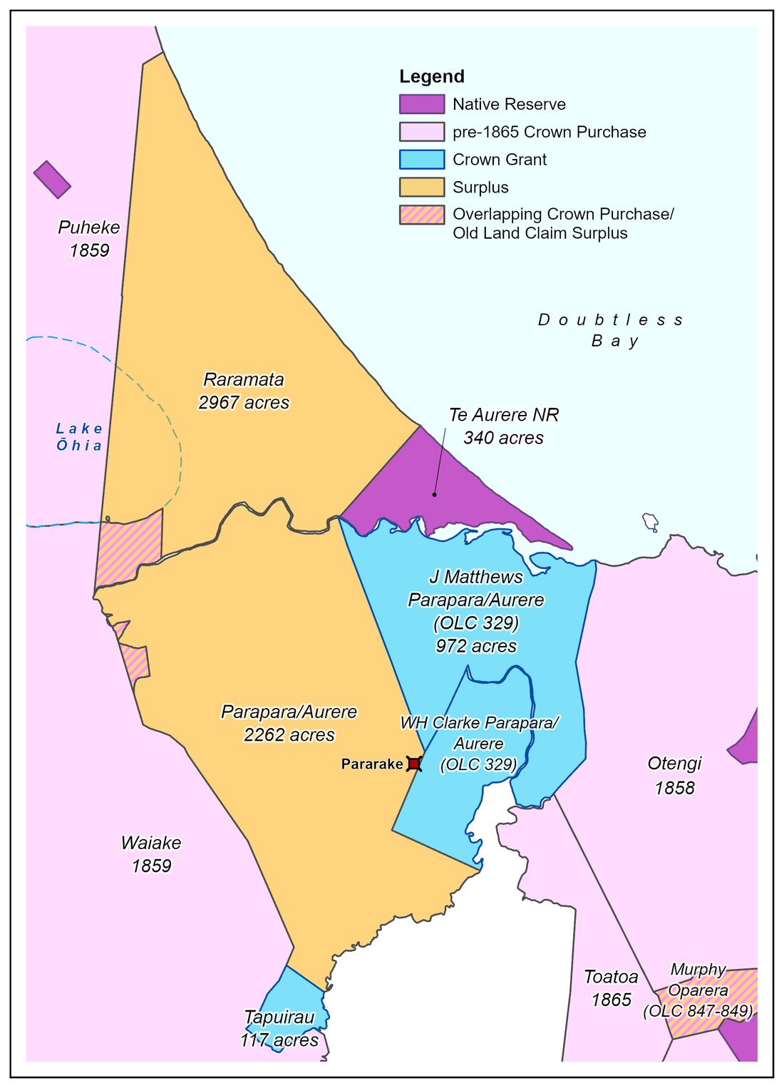
Two men got 1,748 acres. The whole community got 340.
Of the 7,317 acres eventually surveyed within the Matthews claim, Matthews himself was awarded 1,089 acres and his surveyor, Clarke — paid in land for his work — got 659 acres. Between them, two Pākehā individuals received 1,748 acres. The Māori reserve, what became Okokori, was fixed at 340 acres — under a fifth of what those two men alone were given. The Crown kept the remaining 5,229 acres as "surplus."
Godfrey recommended less. The Governor tripled it anyway.
This wasn't unique to Matthews — it was the pattern. Commissioner Godfrey investigated old land claims and recommended grants based on the evidence; Governor FitzRoy then routinely enlarged them regardless. Ryan's claim went from £514 recommended to £1,542 awarded. Berghan's went from £438 to £1,146. Ford's Oruru claim went from 575 acres recommended to 1,725 acres awarded. Every increase came out of what would otherwise have stayed Māori land.
One title, a dozen Court orders
By the 1950s, generations of inheritance had splintered Parapara ownership into hundreds of scattered shares across many small blocks. "Consolidation" swapped these interests around so each whānau ended up holding one block instead of slivers of many — but even a single new title could take ten or more separate vesting, exchange and succession orders to arrange. The 1954 Parapara scheme cut the number of owners across the whole block by around 90 per cent, on the Crown's own figures.
413 acres, converted without a single owner's signature
Under the Māori Affairs Amendment Act 1967, any Māori land block with four or fewer owners could be converted to general land on the application of the Māori Land Court's own Registrar — no owner consent required, and often no owner knowledge either. At Parapara, six blocks — 413 acres — were converted this way between 1967 and 1971. Three have since been brought back under Māori title, the most recent in 1998, only after descendants applied fresh to the Court to undo it. Two blocks — nearly 300 acres — remain general land today.
Figures above drawn from Suzanne Woodley, "Muriwhenua Post-1865 Block Narratives, Report Three" (Waitangi Tribunal, Wai 45 #T32, 29 June 2026), Chapter 26 (Parapara East and Parapara West).
What actually protects these sites now?
Two laws currently offer some protection: the Heritage New Zealand Pouhere Taonga Act 2014, which makes it an offence to damage a registered archaeological site, and the Far North District Plan (2009), which lists some sites and requires consultation with tangata whenua nearby. But the gaps are real — of 371 heritage sites listed for the whole Far North district, none of our wāhi tapu at Pararake or Hikurangi are among them, and none of the district's 14 heritage covenants cover them either. Between 1986 and 2024, Heritage New Zealand received 83 applications to modify or destroy sites in our rohe. It has never once declined one. Protection on paper hasn't always meant protection on the ground.
Summaries drawn from Ben Leonard, "Ngāti Tara: Wāhi Tapu and Portable Taonga, Volume I" (Crown Forestry Rental Trust, February 2025); Justin Maxwell & Jennifer Huebert, "Ngāti Tara: Wāhi Tapu and Portable Taonga, Volume II: Archaeological Report" (Crown Forestry Rental Trust, March 2025); and Suzanne Woodley, "Muriwhenua Post-1865 Block Narratives, Report Three" (Waitangi Tribunal, Wai 45 #T32, 29 June 2026). Full citations available in the complete reports.