Origins
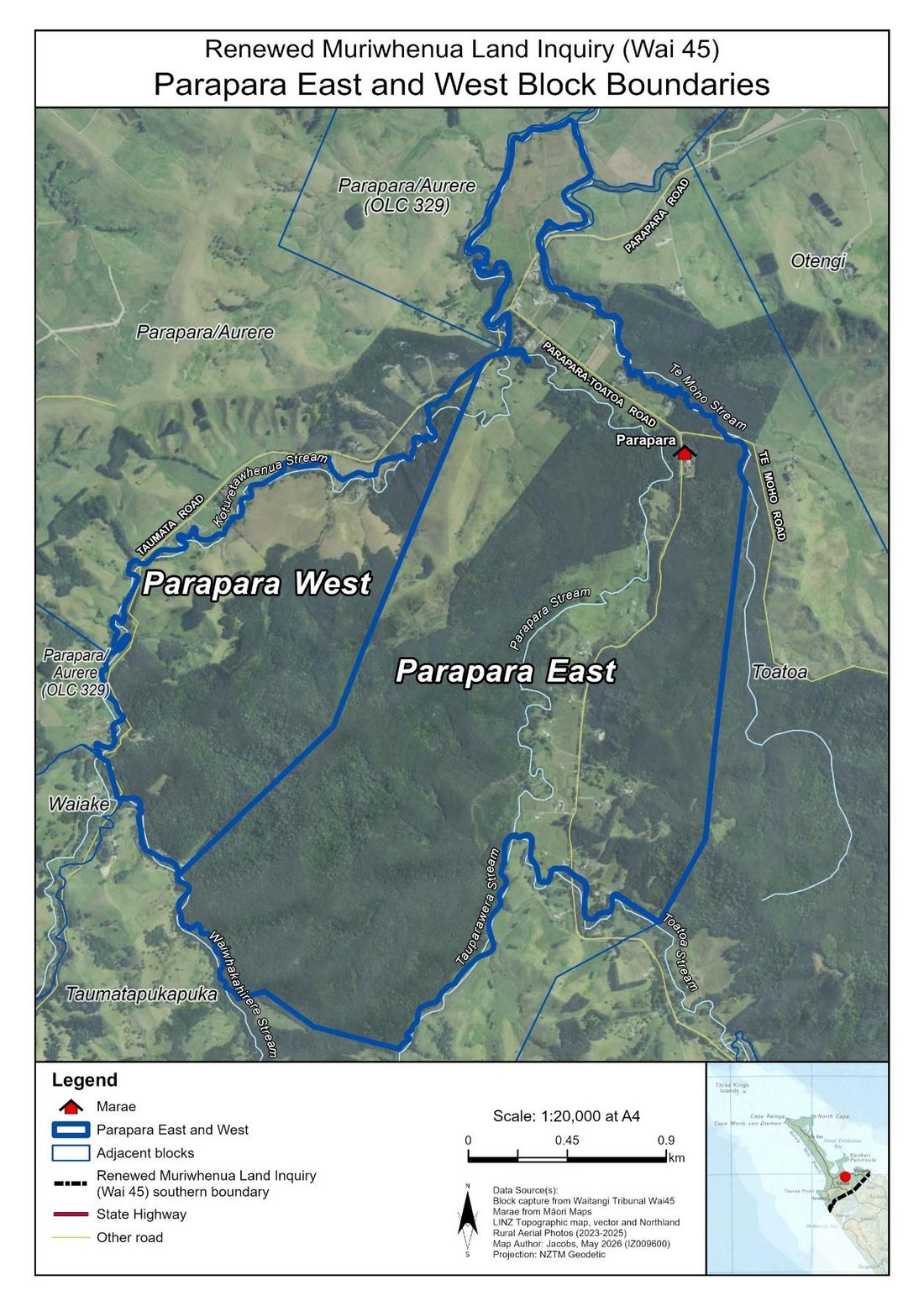
Ngāti Tara trace descent to three ancestral waka that made landfall in this district generations before European contact: Māmaru (captained by Te Parata), Waipapa (whose tohunga Kahukura is a significant ancestor), and Ruakaramea (captained by Moehuri). Te Parata's marriage to Kahutianui gave rise to the peoples of Tokarau and Rangaunu, including Ngāti Tara, Te Paatu and Ngāti Kahu. Ngāti Tara take their name either from Taratara, the maunga behind Parapara Marae, or from the ancestor Tarawauatea. Long before any of the events below, this rohe — from Tokarau Moana across to Rangaunu, inland to the Maungataniwha range — was, in the words of the research, "densely settled," with pā on nearly every headland and gardens filling the Oruru valley.
Ko Tīrepa Wahine te maunga,
Ko Te Moho me Parapara ngā awa,
Ko Parapara te marae,
Ko Mānia, ko Te Morenui ngā tūpuna,
Ko Te Manawa O Ngāti Tara te whare tupuna,
Ko Takapuna te urupā,
Ko Tokerau te moana,
Ko Mamaru te waka,
Ko Te Parata te rangatira,
Ko Kahutianui te tupuna,
Ko Ngāti Tara ko Ngāti Te Rūrūnga ngā hapū,
Ko Ngāti Kahu te iwi.
Sourced from the Briefs of Evidence of Raniera Bassett and Robert Gabel to the Waitangi Tribunal.
Four maunga are named as sacred to Ngāti Tara — Hikurangi, Maungataniwha, Te Ahuponga and Taratara — alongside the pā Kaurinui and Pararake. Several are said to have been built by the rangatira Kauri of Ngāti Awa, who lived at Parapara roughly 500 years ago. Hikurangi itself carries its own legend: local historian Florence Keene records a battle there in which Ngāti Kahu, driven from the pā, buried their weapons, canoes and dead under cover of darkness so their enemy could not take them, and had a tohunga chant the spot tapu. Its exact location has never been found — though, as Keene writes, generations of children avoided sucking honey from the flax flowers growing there, or digging in the sand nearby, out of respect for what might still lie beneath.
Two hundred years
A bay is named — badly
James Cook, unable to enter the harbour due to poor weather, wrote in his journal that it was "doubtless a bay." The name stuck. The original name, Tokarau, refers to the many fishing grounds ("toka") along its shore — a far richer name than Cook's offhand remark.
Sawyers, traders, and two rangatira
Pākehā sawyers and traders began settling around Mangonui from 1831, arranging land dealings with local rangatira — mostly Pororua of Ngāpuhi in the east. Missionaries arrived further west, dealing mainly with Nopera Panakareao. The rivalry between these two rangatira for authority over the contested lands around Oruru and Mangonui would shape the next decade.
"The remainder for the Natives" — Matthews' Parapara deed
Missionary Joseph Matthews concluded a deed for Parapara, Raramata, Tapuirau and Te Mata, signed by Panakareao and 27 others including several Ngāti Tara ancestors — Wiremu Pikaahu, Reihana Morenui (Reihana Kiriwi), and Parata Taha among them. The deed's own words: ten acres for Matthews, "the remainder for the Natives" — forever.
Te Tiriti o Waitangi signed at Kaitaia
Panakareao's first wife Ereonora signed at Kaitaia in April 1840, along with many others named throughout this history. Governor Hobson's visit was marked with a feast — twelve tons of potatoes, kete of kūmara, eight hogs — that Panakareao would later say the Crown treated as full payment for the district's land.
Four hundred warriors, no shots fired
Land Claims Commissioner Godfrey arrived at Mangonui to investigate old land claims. Panakareao and Pororua each mustered upwards of 200 fighting men to assert their rights over the disputed area. The two camps did not exchange fire, but Godfrey could not investigate a single claim in the disputed zone.
Te Waha Kai Onepu — the battle on Taipa beach
Tensions between Panakareao and Pororua broke into open warfare, with a battle fought on Taipa beach itself. Reverend Henry Williams intervened to stop the fighting; between 15 and 46 people are recorded as killed across the conflict. Koiwi from the battle were still being found in the dunes at Taipa as late as the 1920s.
Matthews appeals, and wins the full 800 acres
Commissioner Godfrey had recommended a grant of just 306½ acres to Matthews, with the rest reserved for Māori. Matthews appealed in person to Governor FitzRoy and was awarded the full 800 acres he had originally claimed — the first step in a promise steadily shrinking.
The Oruru valley, sold twice over
Resident Magistrate White struck an unauthorised deal with Panakareao for the Oruru valley in 1854, paying £100 from his own pocket. When Pororua, Ngāti Kahu and Te Rarawa pressed their own claims, the Crown returned in 1856 with a further £350 "to set this at rest" — a token payment for a valley of nearly 15,000 acres.
Panakareao dies
More than a thousand people attended his tangi. His death left, in the Crown's own words, "some difficulty respecting who shall succeed to his authority at Oruru" — a vacuum the Crown moved quickly to fill.
A 7,317-acre claim, reduced to 340
When Commissioner Bell reviewed the Matthews claim, he was told Pararake was sacred and "often requested" to be reserved. An 1858 map even labelled it "Native Reserve Hill." Bell allowed only 300 acres of reserve — what became Okokori — leaving 5,229 acres of "surplus" for the Crown, out of the 7,317 acres finally surveyed. Reihana Kiriwi asked for it all back. He was refused.
"The Natives being very sickly" — and still, no hurry
Resident Magistrate White urged the Crown to pay for Hikurangi "as soon as possible, the Natives being very sickly," so the money could buy nourishing food. The survey was done, the price agreed — £250 for 4,705 acres. The deed wasn't signed and paid for another seven months, in March 1861. A reserve of 522 acres was set aside at its northern end.
A reserve carved out for one man, then sold anyway
The Otengi deed set aside 79 acres at Waimutu for one signatory, Tipene Te Taha, even though other Ngāti Tara held customary interests in it and gathered kaimoana there. In 1863, a local trader offered Tipene £59 for it privately — illegal, since it was a protected reserve. Instead, the Crown bought it from him for less, and resold it to the trader at a markup.
Sold by people who never signed the original deed
The Native Land Court granted title to seven people at Hikurangi, with no restriction on sale despite the urupā there. Three months later, all seven sold it. None of them had signed the 1861 deed.
Reihana Kiriwi dies, days before his own claim is heard
Reihana Kiriwi had lodged the application for the Parapara block's title investigation in 1876. He died before it could be heard — accounts vary between 30 March and 5 April — leaving a younger, less experienced relative, Henare Kepa, to carry the case the following year.
"I am not learned in genealogies"
Opening the Parapara title case, Henare Kepa admitted to the Court he could not trace the whakapapa Reihana Kiriwi would have known by heart. The block was ultimately split — 1,240 acres as Parapara East, largely to Ngāti Tara-aligned owners, and 403 acres as Parapara West, much of which was later sold.
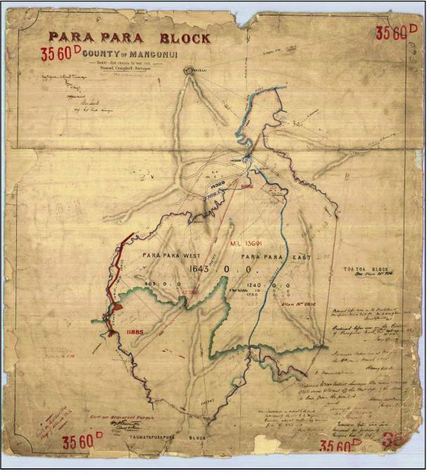
"He did not do so" — a debt between claimants
Not every grievance in this history was with the Crown. Henare Kepa told the Court that he and the late Reihana Kiriwi had earlier admitted Wiremu Pikaahu into their own successful Otarapoko land claim, expecting the same courtesy back when Pikaahu's own Toatoa claim went through. Pikaahu didn't return it. The breakdown of that reciprocity — as much as any Crown dealing — shaped who ended up with what at Parapara.
Okokori's title investigated — and a boundary quietly drawn wrong
Forty years after being reserved, Okokori finally came before the Native Land Court. Surveyors recorded cultivations, old house sites, and two urupā within the block — one of which, unnoticed at the time, had actually been left just outside the surveyed boundary.
The undercount corrected — 127 people, not 24
Decades of censuses had recorded as few as 24 people at Parapara. A proper 1898 list, compiled when residents applied for kauri gum land to support the Native School, recorded 127 — 29 men, 28 women, 70 children. The census data, it turned out, had never come close to the truth.
Piri Raiti's dying wish
Piri Raiti tried to sell Parapara West 2 to the Crown in 1896 for money to survey his own land. The Crown declined, calling it low-value, and suggested he find a private buyer instead. The survey dragged on for years. In 1904, dying, he wrote to the Surveyor-General begging for it to be approved quickly so the matter could be settled before his death. It wasn't finalised until after he died. His children inherited the debt along with the land, and sold it in 1905 — at roughly half the price comparable Parapara land fetched that same year — just to clear what their father owed trying to secure his own title.
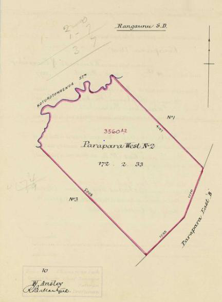
Takapuna urupā — the one that got protected
Takapuna urupā and the 1880 St Matthews Church were set apart and made "absolutely inalienable" — one of only two sites in the whole rohe the 1908 Stout-Ngata Commission would recommend reserving specifically as wāhi tapu.
Pararake quarried
The hill promised as a reserve, labelled "Native Reserve Hill" on an 1858 map, was never protected. In 1906 two acres of its summit were set aside under the Public Works Act as a quarry, its rock used for local road-building.
Wāhi tapu, recorded on paper
The Stout-Ngata Commission recorded a portion of Parapara East as "wāhi tapu" — an official acknowledgement that would sit unenforced for over a century, until Suzanne Woodley's 2026 report brought it back to light.
"Ngāti Kahu" revived
Following the 1919 royal visit, the iwi name Ngāti Kahu was revived and broadened to cover the district's hapū collectively — including Ngāti Tara, whose own distinct identity had, by the Tribunal's own admission, been "obscured" in official records ever since.
Hemaima Matene's missing money
Hemaima Matene gifted her share of Parapara West 3A to her brother in 1919 — "natural love and affection," the record says, no payment involved. In 1923 he sold it to a Pākehā buyer for £90. Weeks later, her solicitor wrote to the Land Board: she'd never seen any of the money, and believed the land had been "sold to or sold through her brother." The Board's reply was that the sale was already confirmed, two weeks earlier. Nothing further is on file.
Asking Parliament
Heta Kiriwi and 23 others petitioned Parliament that the Parapara land had never really been sold. A separate 1923 Hikurangi petition, signed by 24 people, described an old urupā, a papakāinga called Waimihia, and a landing place still in use — and stated plainly the land had been "taken by a European." Officials investigating the petition initially doubted it was even the right block, claiming it "apparently has no landing place or papakāinga called Waimihia" — despite Waimihia being named in the original 1861 purchase deed itself. The Native Affairs Committee made no recommendation. As the independent historian Suzanne Woodley later put it, this was "one of a number of instances where inquiry district Māori were unaware that their land had been alienated."
The petition, adjourned, is never resumed
The 1923 Parapara petition's hearing was adjourned in 1938 and simply never came back.
Pereene Huirama testifies
The only oral evidence a Ngāti Tara claimant gave to the Surplus Lands Commission, about the burial ground at Pararake — a decade after the previous attempt to be heard had simply been shelved.
Consolidation, and six blocks quietly lost
The 1954 Parapara Consolidation Scheme reduced the number of owners across the block by around 90 per cent — Commissioner Bell's own justification was that fewer owners meant more "material production" and "better living conditions." Between 1967 and 1971, six of the resulting Parapara blocks — 413 acres — were converted from Māori land to general land, five of them purely because they had four or fewer owners, under a law that required no consent from those owners.
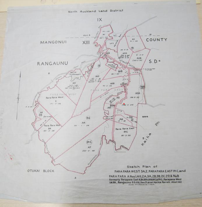
Rachel Harrison's land, sold against her word
Rehutai Manemane Maheno — Rachel Harrison — gave two blocks to her son in the 1950s on the understanding he would farm the land, not sell it. By 1962 he was in financial difficulty and moved to sell anyway. Rachel formally objected. The Department of Māori Affairs' own file records her position plainly: her son "is the man nominated by her... to farm the land but not to sell it." The sale went ahead in 1964. When the local MP, Matiu Rata, was asked to intervene, the Māori Land Court's reply was blunt: "There is no way in which she could get the land back... At best, Rehutai might have been relying on a promise made to her by her son." In 1997, her descendants successfully applied to bring part of the family's remaining land back under Māori title.
Hekenukumai Puhipi's fight for the urupā
Master waka builder Hekenukumai Puhipi — later Sir Hec Busby — found in 1978 that the Okokori boundary had excluded an urupā by around 160 metres. His 1986 letter to the Crown asking for correction, noting "the remains of some of my Ancestors are still buried there," went unresolved. It still is.
Puketū Island protected
Formally investigated by the Māori Land Court and set aside as a Māori reservation for its historical importance — one of the few outright wins in this history, and one of the desecration sites later named directly in the Wai 2000 Statement of Claim.
Three blocks, slowly returned
Three of the six blocks converted to general land in the 1960s–70s were eventually brought back under Māori title, after descendants applied to the Court. Two — nearly 300 acres between them — remain general land today.
A summit spared
When most of the Hikurangi block was cleared for pine planting, an archaeological survey found a former burial ground on its southern flank. After Ngāti Kahu raised cultural and spiritual concerns, the planting company agreed not to develop the upper slopes — protection granted before damage was done, for once, not after.
Wai 2000, and the research that followed
Chappy Harrison lodged Wai 2000 in 2008. The research commissioned since — Leonard's wāhi tapu report, Stirling's customary lands project (finalising 24 August 2026), Woodley's independent title history — is what this page, and the rest of this site, draws on. See Claim Journey for that fuller story.
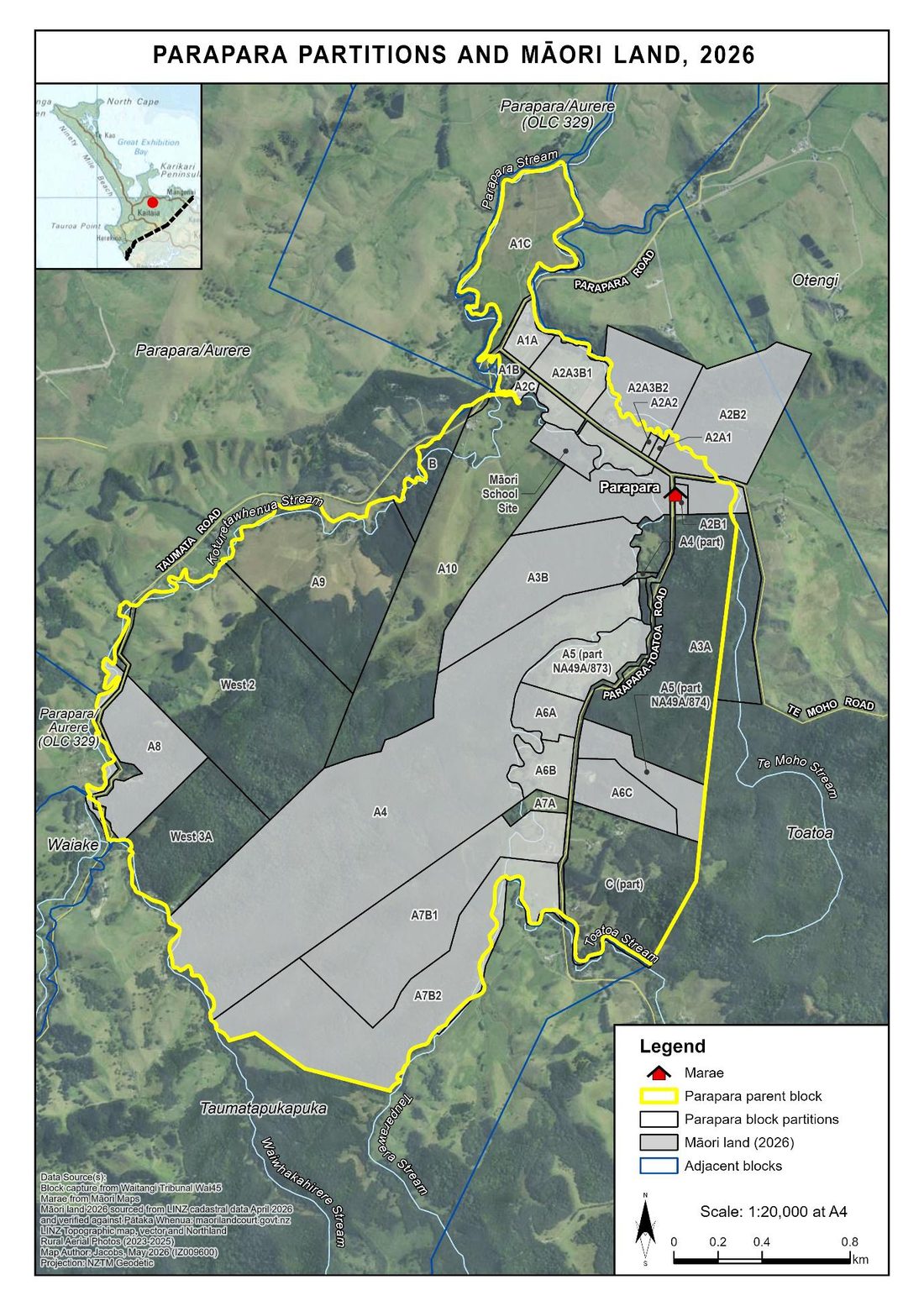
Synthesised from Bruce Stirling, "Ngati Tara Customary Lands" (draft, July 2026); Ben Leonard, "Ngāti Tara: Wāhi Tapu and Portable Taonga, Volume I" (Crown Forestry Rental Trust, February 2025); Justin Maxwell & Jennifer Huebert, "Ngāti Tara: Wāhi Tapu and Portable Taonga, Volume II: Archaeological Report" (Crown Forestry Rental Trust, March 2025); and Suzanne Woodley, "Muriwhenua Post-1865 Block Narratives, Report Three" (Waitangi Tribunal, Wai 45 #T32, June 2026) — with underlying sources including the Waitangi Tribunal's Muriwhenua Land Report (1997) and Mangonui Sewerage Report (1988), and briefs of evidence from Raniera Bassett, Robert Gabel, Atihana Johns and Chappy Harrison (Wai 45, 2012). Full citations available in the complete reports.